File:Russian Tsardom 1500 to 1700.png
Jump to navigation
Jump to search


Size of this preview: 800 × 314 pixels. Other resolutions: 320 × 125 pixels | 1,000 × 392 pixels.
Original file (1,000 × 392 pixels, file size: 93 KB, MIME type: image/png)
| This is a file from the Wikimedia Commons. Information from its description page there is shown below. Commons is a freely licensed media file repository. You can help. |
 |
This locator map image could be re-created using vector graphics as an SVG file. This has several advantages; see Commons:Media for cleanup for more information. If an SVG form of this image is available, please upload it and afterwards replace this template with
{{vector version available|new image name}}.
It is recommended to name the SVG file "Russian Tsardom 1500 to 1700.svg" – then the template Vector version available (or Vva) does not need the new image name parameter. |
Summary
| Description |
Polski: Rozwój Rosji w
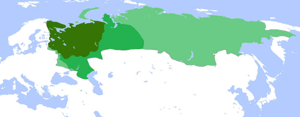
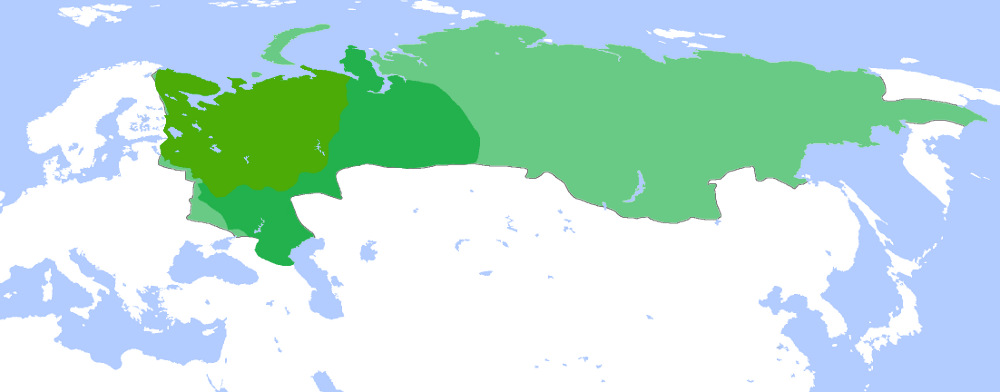
Русский: Территория Русского царства в
Українська: Територія Московського царства у
|
| Date | 16 April 2011, 13:25 (UTC) |
| Source |
|
| Author |
|
| Other versions | See also: File:Russia 1533-1896.gif. |
| This is a retouched picture, which means that it has been digitally altered from its original version. Modifications: combination of three maps. The original can be viewed here: RussianEmpire1600.png:
|
 |
Permission is granted to copy, distribute and/or modify this document under the terms of the GNU Free Documentation License, Version 1.2 or any later version published by the Free Software Foundation; with no Invariant Sections, no Front-Cover Texts, and no Back-Cover Texts. A copy of the license is included in the section entitled GNU Free Documentation License. |
If this file is eligible for relicensing, it may also be used under the Creative Commons Attribution-ShareAlike 3.0 license. The relicensing status of this image needs to be manually reviewed by an experienced user. You can help.
|
Original upload log
This image is a derivative work of the following images:
- File:Rus1500-1900.PNG licensed with GFDL
- 2011-01-08T17:45:59Z Mixx321 588x248 (43534 Bytes) {{Information |Description={{en|1=Growing of Russia 15th-20th century}} {{pl|1=Rozwój Rosji w XV-XX wieku}} |Source={{own}}, Atlas historyczny dla szkół średnich, wyd. PPWK/Nowa Era, {{ISBN|83-7409-138-X}} |Author=[[User:Mix
- File:RussianEmpire1700.png licensed with Cc-by-3.0
- 2009-04-24T15:48:13Z Gabagool 2264x1064 (86713 Bytes) {{Information |Description={{en|1=Locator map of Russia, c. 1700. (Partially based on ''Atlas of World History'' (2007) - The World 1600-1700, map)}} |Source=Own work by uploader |Author=[[User:Gabagool|Gabagool]] / Jarle Gr
- File:RussianEmpire1600.png licensed with Cc-by-3.0
- 2009-04-24T15:47:18Z Gabagool 2264x1064 (85101 Bytes) {{Information |Description={{en|1=Locator map of Russia (big), c. 1600. (Partially based on ''Atlas of World History'' (2007) - The World 1500-1600, map)}} |Source=Own work by uploader |Author=[[User:Gabagool|Gabagool]] / Ja
Uploaded with derivativeFX
File history
Click on a date/time to view the file as it appeared at that time.
| Date/Time | Thumbnail | Dimensions | User | Comment | |
|---|---|---|---|---|---|
| current | 18:41, 19 February 2016 | 1,000 × 392 (93 KB) | Fährtenleser | better colours | |
| 13:25, 16 April 2011 | 1,000 × 392 (90 KB) | Dbachmann | {{Information |Description={{en|1= Territory of the Tsardom of Russia in {{legend|#4dab07}} AD 1500, *{{legend0|#22b14c}} 1600 and *{{legend0|#68ca84}} 1700. }} {{pl|1=Rozwój Rosji w XV-XX wieku}} {{en|1=Locator map of Russia, c. 1700. (Partially bas |
File usage
The following pages on the English Wikipedia use this file (pages on other projects are not listed):
Global file usage
The following other wikis use this file:
- Usage on ar.wikipedia.org
- Usage on azb.wikipedia.org
- Usage on az.wikipedia.org
- Usage on az.wiktionary.org
- Usage on be-tarask.wikipedia.org
- Usage on be.wikipedia.org
- Usage on bg.wikipedia.org
- Usage on bs.wikipedia.org
- Usage on cs.wikipedia.org
- Usage on da.wikipedia.org
- Usage on de.wikipedia.org
- Usage on el.wikipedia.org
- Usage on en.wikibooks.org
- Usage on es.wikipedia.org
- Usage on eu.wikipedia.org
- Usage on fa.wikipedia.org
- Usage on fi.wikipedia.org
- Usage on hi.wikipedia.org
- Usage on hu.wikipedia.org
- Usage on id.wikipedia.org
- Usage on io.wikipedia.org
- Usage on it.wikipedia.org
- Usage on ja.wikipedia.org
- Usage on ko.wikipedia.org
- Usage on la.wikipedia.org
- Usage on lt.wikipedia.org
- Usage on lv.wikipedia.org
- Usage on mk.wikipedia.org
- Usage on mn.wikipedia.org
- Usage on ms.wikipedia.org
- Usage on nl.wikipedia.org
- Usage on pa.wikipedia.org
- Usage on pl.wikipedia.org
- Usage on pnb.wikipedia.org
- Usage on pt.wikipedia.org
- Usage on ro.wikipedia.org
- Usage on rue.wikipedia.org
- Usage on ru.wikipedia.org
View more global usage of this file.